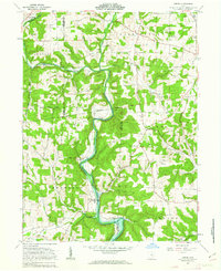
1961 Map of Greer
USGS Topo · Published 1963About this map
The Greenville Treaty Line cuts across this landscape, marking a significant historical boundary that separates the townships of Jefferson and Knox. The Mohican River and its tributary, the Black Fork Mohican River, define the local topography, winding through a region dotted with small family settlements and religious retreats. Small communities like Greer and Spellacy serve as focal points for local history, while several burial grounds, including Ullman Cem and Harding Cem, offer valuable data for genealogists tracing early residents. The southern portion of the map is noted as being subject to controlled inundation by Mohawk Dam. Industrial footprints are visible at the Gravel Pit near the river, and the Pennsylvania railroad line provides a glimpse into the mid-century transportation network that connected these rural townships.
Find a feature on this map
28 named features on this map. Tap any name to fly to it.
Don’t see what you’re looking for? This feature index may not catch every label — zoom into the map to look around manually.
Map Details
Editions of this 1961 Greer Map
Other maps of this area

1912 · Loudonville
USGS Topo · 1:62,500

1912 · Gambier
USGS Topo · 1:62,500

1912 · Perrysville
USGS Topo · 1:62,500

1913 · Brinkhaven
USGS Topo · 1:62,500

1914 · Gambier
USGS Topo · 1:62,500

1914 · Loudonville
USGS Topo · 1:62,500

1915 · Brinkhaven
USGS Topo · 1:62,500

1915 · Perrysville
USGS Topo · 1:62,500

1943 · Gambier
USGS Topo · 1:62,500

1943 · Loudonville
USGS Topo · 1:62,500