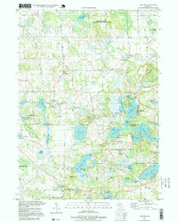
1996 Map of Gregory
USGS Topo · Published 1999About this map
The settlement of Gregory and the surrounding township of Unadilla define this landscape on the border of Livingston and Washtenaw counties. In the late 20th century, the area remains a mosaic of public lands and glacial lakes, with the Pinckney State Recreation Area and Gregory State Wildlife Management Area preserving significant portions of the terrain. The transport history of the region is etched into the ground by the Old RR Grade passing through Bullis Crossing and the small hamlet of Anderson.
Find a feature on this map
79 named features on this map. Tap any name to fly to it.
Don’t see what you’re looking for? This feature index may not catch every label — zoom into the map to look around manually.
Map Details
Editions of this 1996 Gregory Map
This is the sole edition of this map. No revisions or reprints were ever made.
Other maps of this area

1902 · Dexter
USGS Topo · 1:62,500

1904 · Ann Arbor
USGS Topo · 1:125,000

1906 · Dexter
USGS Topo · 1:62,500

1907 · Howell
USGS Topo · 1:62,500

1908 · Ann Arbor
USGS Topo · 1:125,000

1908 · Fowlerville
USGS Topo · 1:62,500

1909 · Howell
USGS Topo · 1:62,500

1910 · Fowlerville
USGS Topo · 1:62,500

1919 · Stockbridge
USGS Topo · 1:62,500

1922 · Stockbridge
USGS Topo · 1:62,500
Featured Places
- Putnam Township, MI
- Dexter Township, MI
- Unadilla, Unadilla Township
- Unadilla Township, MI
- Lyndon Township, MI