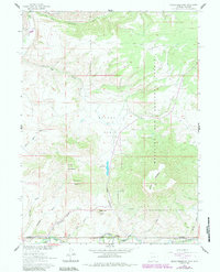
1961 Map of Grieve Reservoir
USGS Topo · Published 1984About this map
The Little Snake River defines the southern boundary of this remote high-country landscape, where the Wyoming Colorado state line meets the rugged intersections of Carbon, Moffat, and Routt counties. This 1961 field-checked survey reveals a territory shaped by high-altitude ranching and water management, anchored by the Grieve Reservoir and the extensive Belvidere Ditch system. Local heritage is marked by small outposts like the Savery Corral, Divide Hdqrs, and Boyer Ranch, while the Anderson Cem offers a primary point of interest for genealogists tracing early families in the region. Much of the eastern terrain falls within the Medicine Bow National Forest, characterized by prominent peaks like Sugarloaf Mountain and Battle Mountain. The intricate network of drainage draws, such as McIntosh Gulch and Rye Grass Gulch, illustrates the complex topography of the Reader Basin.
Find a feature on this map
28 named features on this map. Tap any name to fly to it.
Don’t see what you’re looking for? This feature index may not catch every label — zoom into the map to look around manually.
Map Details
Editions of this 1961 Grieve Reservoir Map
2 editions found

Other maps of this area

1932 · Savery
USGS Topo · 1:96,000

1940 · Savery
USGS Topo · 1:125,000

1954 · Rawlins
USGS Topo · 1:250,000

1954 · Craig
USGS Topo · 1:250,000

1957 · Craig
USGS Topo · 1:250,000

1958 · Rawlins
USGS Topo · 1:250,000

1958 · Craig
USGS Topo · 1:250,000

1960 · Craig
USGS Topo · 1:250,000
1961 · Savery
USGS Topo · 1:24,000
1961 · Browns Hill
USGS Topo · 1:24,000