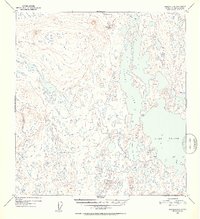
1952 Map of Gulkana B-6
USGS Topo · Published 1953About this map
Lake Louise and Susitna Lake dominate this 1952 topographic study, revealing a complex network of glacial lakes and marshy lowlands in the Gulkana region. The map captures the shoreline of these massive water bodies shortly after the territory's interior began seeing more frequent aerial mapping for resource and transport planning. Sparse signs of human activity are present only in the form of isolated Cabin locations positioned near the southern and eastern shores of Susitna Lake and Little Lake Louise. The terrain is defined by hundreds of unnamed ponds and smaller basins like Grayling Lake, Curtis Lake, and Tyone Lake, illustrating the post-glacial hydrology of the Copper River basin before more modern infrastructure reached this part of the Alaska interior. For historians, these early 1950s surveys provide the baseline for understanding the landscape prior to the expansion of recreational and seasonal settlements.
Find a feature on this map
7 named features on this map. Tap any name to fly to it.
Don’t see what you’re looking for? This feature index may not catch every label — zoom into the map to look around manually.
Map Details
Editions of this 1952 Gulkana B-6 Map
3 editions found
Other maps of this area

1949 · Gulkana A-5
USGS Topo · 1:63,360

1949 · Talkeetna Mountains A-1
USGS Topo · 1:63,360

1949 · Gulkana A-6
USGS Topo · 1:63,360

1950 · Talkeetna Mountains
USGS Topo · 1:250,000

1950 · Gulkana B-6
USGS Topo · 1:63,360

1951 · Gulkana
USGS Topo · 1:250,000

1951 · Talkeetna Mountains B-1
USGS Topo · 1:63,360

1951 · Gulkana B-5
USGS Topo · 1:63,360

1951 · Gulkana C-5
USGS Topo · 1:63,360

1951 · Talkeetna Mountains C-1
USGS Topo · 1:63,360