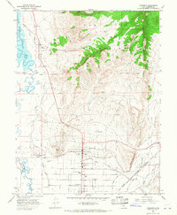
1966 Map of Gunnison
USGS Topo · Published 1968About this map
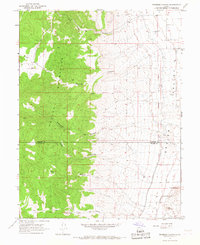
Gunnison and its neighboring agricultural communities anchor this Sanpete County landscape during the mid-1960s, a period defined by an intricate network of irrigation and rail infrastructure. The San Pitch River and Sevier River supply a complex system of waterworks, including the Gunnison Reservoir, Fayette Canal, and City Ditch, which support the valley's farms. Transport is dominated by the Denver and Rio Grande Western railroad, which services Gunnison (Siding) and the residential cores of Centerfield and Fayette. Notable landmarks include the Gunnison Valley High Sch and the Gunnison Cemetery, providing essential geographic anchors for genealogical research. The northern portion of the map is defined by the steep rises of the San Pitch Mountains, featuring unique landforms like The Caterpillar and the historic Old Indian Treaty Boundary that cuts across the terrain.
Find a feature on this map
42 named features on this map. Tap any name to fly to it.
Don’t see what you’re looking for? This feature index may not catch every label — zoom into the map to look around manually.
Map Details
Editions of this 1966 Gunnison Map
2 editions found
Other maps of this area

1885 · Manti
USGS Topo · 1:250,000

1895 · Manti
USGS Topo · 1:250,000

1956 · Price
USGS Topo · 1:250,000

1960 · Price
USGS Topo · 1:250,000

1962 · Price
USGS Topo · 1:250,000
1965 · Hells Kitchen Canyon SW
USGS Topo · 1:24,000

1965 · Hells Kitchen Canyon SE
USGS Topo · 1:24,000
1965 · Mayfield
USGS Topo · 1:24,000

1965 · Manti
USGS Topo · 1:24,000
1966 · Redmond Canyon
USGS Topo · 1:24,000