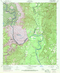
1954 Map of Haddens
USGS Topo · Published 1969About this map
The Sabine River serves as the central artery and state boundary in this 1950s study, revised in the late 1960s to account for the impact of the Toledo Bend Reservoir. The map illustrates a complex landscape of river meanders and sloughs, including Horseshoe Slough and Crossway Slough, which defined the local geography before major hydrological changes. Small rural communities like Toledo and Haddens are documented alongside vital social landmarks such as Mt Olive Church and Freedom Rest Church.
Find a feature on this map
47 named features on this map. Tap any name to fly to it.
Don’t see what you’re looking for? This feature index may not catch every label — zoom into the map to look around manually.
Map Details
Editions of this 1954 Haddens Map
3 editions found
Other maps of this area

1941 · Leesville
USGS Topo · 1:62,500

1942 · Florien
USGS Topo · 1:62,500

1943 · Leesville
USGS Topo · 1:62,500

1944 · Negreet
USGS Topo · 1:62,500

1944 · Wiergate
USGS Topo · 1:62,500

1944 · Florien
USGS Topo · 1:62,500

1946 · Leesville
USGS Topo · 1:62,500

1948 · Leesville
USGS Topo · 1:62,500

1948 · Wiergate
USGS Topo · 1:62,500

1953 · Alexandria
USGS Topo · 1:250,000