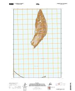
2020 Map of Hagemeister Island C-2 NE
USGS Topo · Published 2020About this map
High Island rises as a solitary, steep-contoured landmark within the Walrus Islands chain, situated where the waters of Bristol Bay meet the Pacific Ocean. This 2020 topographical survey documents the landform's isolation and elevation, with contours reaching significantly above the surrounding sea level. The map depicts the precise shoreline and rugged interior of the island, providing a detailed record for maritime history and geographical study of this corner of the Dillingham Census Area. The lack of infrastructure or man-made settlements on the island emphasizes its role as a natural maritime landmark and wildlife habitat within the larger archipelago of southwestern Alaska.
Find a feature on this map
9 named features on this map. Tap any name to fly to it.
Don’t see what you’re looking for? This feature index may not catch every label — zoom into the map to look around manually.
Map Details
Editions of this 2020 Hagemeister Island C-2 NE Map
This is the sole edition of this map. No revisions or reprints were ever made.
Other maps of this area

1947 · Hagemeister Island D-2
USGS Topo · 1:63,360
1948 · Hagemeister Island C-2
USGS Topo · 1:63,360

1948 · Hagemeister Island C-1
USGS Topo · 1:63,360

1950 · Hagemeister Island D-1
USGS Topo · 1:63,360

1951 · Hagemeister Island
USGS Topo · 1:250,000

1952 · Hagemeister Island C-1
USGS Topo · 1:63,360

1952 · Hagemeister Island C-2
USGS Topo · 1:63,360

1952 · Hagemeister Island D-1
USGS Topo · 1:63,360

1953 · Hagemeister Island D-2
USGS Topo · 1:63,360

1957 · Hagemeister Island
USGS Topo · 1:250,000