
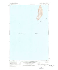
1952 Map of Hagemeister Island C-3
USGS Topo · Published 1955About this map
Hagemeister Island dominates this 1952 topographic study, showing the island's interior elevations and coastal features as they were mapped by the U.S. Coast and Geodetic Survey. This mid-century survey details the landmass as it sits between the waters of Hagemeister Strait to the west and the open Bristol Bay to the east. The terrain is marked by distinctive survey points, including VABM 781 Island in the north and the southern height of VABM 829 Cairn Peak. Based on aerial photographs taken in 1948, the map illustrates the island's natural drainage patterns and the continuous gravel beaches that line its eastern and southern shores. This document serves as a specific record of this remote Alaskan landmass before the advent of modern digital cartography.
Find a feature on this map
5 named features on this map. Tap any name to fly to it.
Don’t see what you’re looking for? This feature index may not catch every label — zoom into the map to look around manually.
Map Details
Editions of this 1952 Hagemeister Island C-3 Map
This is the sole edition of this map. No revisions or reprints were ever made.
Other maps of this area

1947 · Hagemeister Island D-2
USGS Topo · 1:63,360

1948 · Hagemeister Island D-3
USGS Topo · 1:63,360

1948 · Hagemeister Island C-4
USGS Topo · 1:63,360

1948 · Hagemeister Island C-3
USGS Topo · 1:63,360
1948 · Hagemeister Island C-2
USGS Topo · 1:63,360

1951 · Hagemeister Island
USGS Topo · 1:250,000

1952 · Hagemeister Island C-2
USGS Topo · 1:63,360

1952 · Hagemeister Island C-4
USGS Topo · 1:63,360

1953 · Hagemeister Island D-2
USGS Topo · 1:63,360

1954 · Hagemeister Island D-4
USGS Topo · 1:63,360