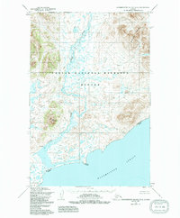
1954 Map of Hagemeister Island D-4
USGS Topo · Published 1991About this map
Togiak National Wildlife Refuge encompasses the majority of this coastal Alaskan landscape, where the rugged topography of the Ahklun Mountains meets the Bering Sea. The terrain is defined by prominent peaks like Downdraft Mountain and Virgo Mountain, which overlook a complex network of tundra ponds and drainages. The Osyak River meanders southward through the refuge toward the coastal settlement of Osyak, situated near the shoreline of Hagemeister Strait. This survey reflects a mid-century period of land management, including the Refuge Boundary and the prominent headland at Estus Point. The map provides an essential view of the traditional subsistence landscape and the natural hydrology of the Togiak wilderness before later decades of environmental change.
Find a feature on this map
8 named features on this map. Tap any name to fly to it.
Don’t see what you’re looking for? This feature index may not catch every label — zoom into the map to look around manually.
Map Details
Editions of this 1954 Hagemeister Island D-4 Map
2 editions found

Other maps of this area

1948 · Hagemeister Island D-3
USGS Topo · 1:63,360

1948 · Hagemeister Island C-4
USGS Topo · 1:63,360

1948 · Hagemeister Island C-3
USGS Topo · 1:63,360

1948 · Hagemeister Island C-5
USGS Topo · 1:63,360

1950 · Hagemeister Island D-5
USGS Topo · 1:63,360

1951 · Goodnews
USGS Topo · 1:250,000

1951 · Hagemeister Island
USGS Topo · 1:250,000

1952 · Hagemeister Island C-3
USGS Topo · 1:63,360
1952 · Hagemeister Island C-5
USGS Topo · 1:63,360

1952 · Hagemeister Island C-4
USGS Topo · 1:63,360