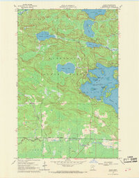
1964 Map of Haley
USGS Topo · Published 1969About this map
The dense timberlands of Kabetogama State Forest dominate this mid-1960s survey of St. Louis County, where the iron-and-timber landscape meets the complex shoreline of Vermilion Lake. The western edge of the lake is marked by prominent family-named features like Jacobsons Point, Ormonds Island, and Schmidts Island, indicating a localized history of early settlement and recreation. Near the inlet of Wakemup Bay, an Indian Cem and a Bible Camp are noted, highlighting the cultural and social layers of the lakefront during this era.
Find a feature on this map
31 named features on this map. Tap any name to fly to it.
Don’t see what you’re looking for? This feature index may not catch every label — zoom into the map to look around manually.
Map Details
Editions of this 1964 Haley Map
4 editions found
Other maps of this area

1954 · Hibbing
USGS Topo · 1:250,000

1954 · International Falls
USGS Topo · 1:250,000

1957 · Hibbing
USGS Topo · 1:250,000

1957 · International Falls
USGS Topo · 1:250,000

1958 · International Falls
USGS Topo · 1:250,000

1958 · Hibbing
USGS Topo · 1:250,000

1964 · Hibbing
USGS Topo · 1:250,000

1964 · Linden Grove
USGS Topo · 1:24,000

1964 · Haley
USGS Topo · 1:24,000

1964 · Gheen
USGS Topo · 1:24,000