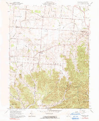
1961 Map of Hallsville
USGS Topo · Published 1990About this map
Tar Hollow State Forest dominates the southeast corner of this survey, where the terrain shifts abruptly from the flat agricultural plains of The Prairie to the deeply dissected ridges of Brush Ridge. This transition in Ross and Pickaway counties creates a distinct landscape where small settlements like Hallsville and Adelphi sit at the edge of the upland forest. Local history is well-preserved through numerous family and community landmarks, including Colerain Ch and a high concentration of cemeteries such as Prairieview Cem, Monnett Cem, and Green Summit Cem. The drainage pattern is defined by Salt Creek and its many tributaries, while more specialized infrastructure like the Brush Ridge Tower and a Gaging Sta on Little Walnut Creek underscore the area’s resource management in the early 1960s.
Find a feature on this map
48 named features on this map. Tap any name to fly to it.
Don’t see what you’re looking for? This feature index may not catch every label — zoom into the map to look around manually.
Map Details
Editions of this 1961 Hallsville Map
Other maps of this area

1906 · Chillicothe
USGS Topo · 1:62,500

1907 · Lancaster
USGS Topo · 1:62,500

1908 · Chillicothe
USGS Topo · 1:62,500

1909 · Lancaster
USGS Topo · 1:62,500

1910 · Laurelville
USGS Topo · 1:62,500

1912 · Laurelville
USGS Topo · 1:62,500

1914 · Circleville
USGS Topo · 1:62,500

1943 · Circleville
USGS Topo · 1:62,500

1944 · Laurelville
USGS Topo · 1:62,500

1947 · Columbus
USGS Topo · 1:250,000