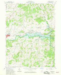
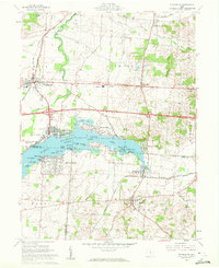
1961 Map of Hanover
USGS Topo · Published 1970About this map
Licking River and the expansive Dillon Reservoir dominate this eastern Licking County landscape, where the water's edge reaches toward the small settlements of Claylick and Marne. The map captures a moment when the regional transportation network was defined by the parallel routes of the Baltimore and Ohio Railroad and the Pennsylvania Railroad, which served the local industry and communities such as Hanover. Local life centers around several rural congregations, including Hazel Dell Ch and Mount Carmel Ch, alongside schools like Licking Valley High Sch. To the south, the terrain rises significantly toward prominent landmarks such as Bald Knob, Bucks Knob, and Coffman Knob, overlooking the winding paths of Claylick Creek and Swamp Run. This survey offers a detailed look at the area's mid-century transition as the reservoir changed the local hydrology and social geography.
Find a feature on this map
39 named features on this map. Tap any name to fly to it.
Don’t see what you’re looking for? This feature index may not catch every label — zoom into the map to look around manually.
Map Details
Editions of this 1961 Hanover Map
5 editions found
Other maps of this area

1909 · Newark
USGS Topo · 1:62,500

1909 · Thornville
USGS Topo · 1:62,500

1910 · Frazeysburg
USGS Topo · 1:62,500

1910 · Zanesville
USGS Topo · 1:62,500

1947 · Columbus
USGS Topo · 1:250,000

1950 · Marion
USGS Topo · 1:250,000

1961 · Columbus
USGS Topo · 1:250,000

1961 · Hanover
USGS Topo · 1:24,000

1961 · Newark
USGS Topo · 1:24,000
1961 · Thornville
USGS Topo · 1:24,000