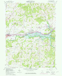
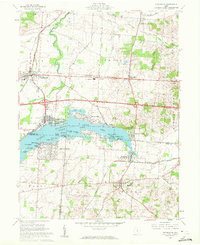
1961 Map of Hanover
USGS Topo · Published 1976About this map
The Licking River winds through the heart of Licking County, defining a landscape marked by the deep Licking Gorge and a concentrated corridor of infrastructure. In this mid-century period, the parallel routes of the Penn Central and the Baltimore and Ohio railroads facilitate movement through the river valley, connecting the settlements of Hanover, Marne, and Claylick. The terrain is punctuated by distinctive high points like Bald Knob, Bucks Knob, and Coffman Knob, while the surrounding hillsides are dotted with numerous Oil Wells and Gas Wells, indicating the region's active energy extraction.
Find a feature on this map
49 named features on this map. Tap any name to fly to it.
Don’t see what you’re looking for? This feature index may not catch every label — zoom into the map to look around manually.
Map Details
Editions of this 1961 Hanover Map
5 editions found
Other maps of this area

1909 · Newark
USGS Topo · 1:62,500

1909 · Thornville
USGS Topo · 1:62,500

1910 · Frazeysburg
USGS Topo · 1:62,500

1910 · Zanesville
USGS Topo · 1:62,500

1947 · Columbus
USGS Topo · 1:250,000

1950 · Marion
USGS Topo · 1:250,000

1961 · Columbus
USGS Topo · 1:250,000

1961 · Hanover
USGS Topo · 1:24,000

1961 · Newark
USGS Topo · 1:24,000
1961 · Thornville
USGS Topo · 1:24,000