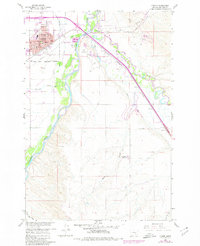
1960 Map of Hardin
USGS Topo · Published 1980About this map
The town of Hardin serves as a vital hub along the Bighorn River in this survey updated to 1980. The settlement is densely developed with civic anchors like the Court House, Memorial Hospital, and St Joseph Ch, while the southern outskirts transition into the Crow Indian Reservation. The river valley is a complex network of irrigation and transportation, featuring the Farmers Canal and the Chicago Burlington and Quincy railroad line that tracks alongside the Little Bighorn River. Of significant interest to local historians is the Historical Mon (Site of Fort Custer) located on the bluffs overlooking the river confluence. The landscape further south is marked by dry coulees like Williams Coulee and Dana Coulee, dotted with smaller outposts such as Dunmore and Campbell Camp No 1.
Find a feature on this map
39 named features on this map. Tap any name to fly to it.
Don’t see what you’re looking for? This feature index may not catch every label — zoom into the map to look around manually.
Map Details
Editions of this 1960 Hardin Map
Other maps of this area

1894 · Fort Custer
USGS Topo · 1:125,000

1954 · Hardin
USGS Topo · 1:250,000

1957 · Hardin
USGS Topo · 1:250,000

1958 · Hardin
USGS Topo · 1:250,000

1960 · Ninemile Point
USGS Topo · 1:24,000

1960 · Chimney Creek
USGS Topo · 1:24,000

1960 · Walker Hill
USGS Topo · 1:24,000

1960 · Hardin
USGS Topo · 1:24,000
1960 · Prante Ranch
USGS Topo · 1:24,000

1960 · Hardin SW
USGS Topo · 1:24,000