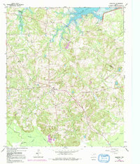
1961 Map of Harleton
USGS Topo · Published 1992About this map
The community of Harleton serves as the focal point of this Harrison County landscape, situated amidst a rolling terrain of piney woods and creek bottoms. The northern boundary of the map is dominated by the reservoir of Lake O' the Pines, where the Ferrells Bridge Dam regulates the water levels. The map captures a transition period for the local geography, showing the expansion of the Gas Field and the placement of several oil wells, which suggest the growing importance of the energy sector to this rural Texas economy.
Find a feature on this map
28 named features on this map. Tap any name to fly to it.
Don’t see what you’re looking for? This feature index may not catch every label — zoom into the map to look around manually.
Map Details
Editions of this 1961 Harleton Map
3 editions found
Other maps of this area

1956 · Tyler
USGS Topo · 1:250,000

1961 · Hallsville
USGS Topo · 1:24,000

1961 · Lassater
USGS Topo · 1:24,000

1961 · Harleton
USGS Topo · 1:24,000

1962 · Kellyville
USGS Topo · 1:24,000

1962 · Marshall NW
USGS Topo · 1:24,000

1962 · Marshall West
USGS Topo · 1:24,000

1962 · Ashland
USGS Topo · 1:24,000

1962 · Longview Heights
USGS Topo · 1:24,000

1962 · Ore City
USGS Topo · 1:24,000