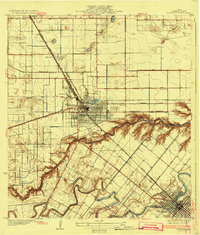
1932 Map of Harlingen
USGS Topo · Published 1932About this map
The rail-driven growth of the Rio Grande Valley is evident in this early 1930s landscape, where the Missouri Pacific and Southern Pacific lines converge at the burgeoning hub of Harlingen. This survey, compiled with data from County Engineer W. O. Washington, illustrates a transition from open ranch land to a structured irrigation-and-rail economy. The dense grid of Harlingen contrasts with smaller stops like Avondale and Combes, while the meandering Arroyo Colorado and the waters of Lake Harlingen provide the critical drainage and resources for the surrounding citrus and vegetable fields. To the south, San Benito shows its own developing street plan along the banks of the Resaca De Los Fresnos. Local landmarks such as the Fairgrounds and the Palmetal Sch reveal the civic foundations of these valley communities during their formative years.
Find a feature on this map
31 named features on this map. Tap any name to fly to it.
Don’t see what you’re looking for? This feature index may not catch every label — zoom into the map to look around manually.
Map Details
Editions of this 1932 Harlingen Map
3 editions found
Other maps of this area

1929 · Rio Hondo
USGS Topo · 1:24,000

1929 · Harlingen
USGS Topo · 1:24,000

1929 · Santa Rosa
USGS Topo · 1:24,000

1929 · Santa Maria
USGS Topo · 1:24,000

1929 · La Feria
USGS Topo · 1:24,000

1929 · La Paloma
USGS Topo · 1:24,000

1930 · Barreda
USGS Topo · 1:24,000

1932 · Combes
USGS Topo · 1:31,680

1932 · Rio Hondo
USGS Topo · 1:31,680

1932 · Harlingen
USGS Topo · 1:31,680