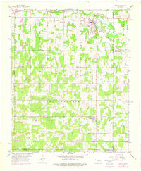
1956 Map of Harrah
USGS Topo · Published 1976About this map
Harrah serves as the primary hub on this map, situated where the Chicago Rock Island and Pacific railroad crosses the North Canadian River. The landscape reveals a mix of agricultural and industrial development, characterized by several Oil Wells and a Gravel Pit near the northern boundary. In the southern half, the settlement of Newalla appears along an east-west transportation corridor, while an Old Railroad Grade and several rural churches, including World Bible Ch and Texas Ch, provide clear evidence of the area's mid-century community structure. The map also documents local infrastructure such as a Landing Strip and the McLoud Cem, reflecting the growth and land use patterns across Oklahoma, Pottawatomie, and Cleveland counties before later urban expansion began to reshape the region.
Find a feature on this map
26 named features on this map. Tap any name to fly to it.
Don’t see what you’re looking for? This feature index may not catch every label — zoom into the map to look around manually.
Map Details
Editions of this 1956 Harrah Map
4 editions found

Other maps of this area

1892 · Moore
USGS Topo · 1:62,500

1892 · Edmond
USGS Topo · 1:62,500

1898 · Purcell
USGS Topo · 1:125,000

1909 · Luther
USGS Topo · 1:62,500

1930 · McLoud
USGS Topo · 1:62,500

1934 · Moore
USGS Topo · 1:62,500

1935 · Edmond
USGS Topo · 1:48,000

1938 · Moore
USGS Topo · 1:62,500

1940 · Edmond
USGS Topo · 1:62,500

1954 · Oklahoma City
USGS Topo · 1:250,000