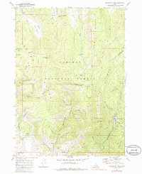
1970 Map of Harrington Peak
USGS Topo · Published 1986About this map
Caribou National Forest dominates this topographic study of the Aspen Range and Preuss Range, where the boundary between Caribou and Bear Lake counties traverses the high ridges. At the center of the sheet, Harrington Peak rises above a landscape defined by dramatic north-south oriented ridgelines and deep drainages like Georgetown Canyon. The map reveals a mountain economy focused on resource extraction and seasonal recreation, evidenced by several Prospects, a Mine Dump, and a Conveyor in the vicinity of Phosphoria Gulch. Natural water sources are critical features in this high country, including Big Spring and Horseshoe Spr. For the local historian, the network of old routes like the Hawks Roost Trail and various unnamed jeep trails illustrates the historical access patterns to these remote watersheds and grazing lands.
Find a feature on this map
47 named features on this map. Tap any name to fly to it.
Don’t see what you’re looking for? This feature index may not catch every label — zoom into the map to look around manually.
Map Details
Editions of this 1970 Harrington Peak Map
2 editions found
Other maps of this area

1909 · Montpelier
USGS Topo · 1:125,000

1911 · Montpelier
USGS Topo · 1:125,000

1911 · Slug Creek
USGS Topo · 1:62,500

1915 · Crow Creek
USGS Topo · 1:62,500

1949 · Johnson Creek
USGS Topo · 1:24,000

1949 · Stewart Flat
USGS Topo · 1:24,000

1949 · Dry Valley
USGS Topo · 1:24,000

1949 · Snowdrift Mountain
USGS Topo · 1:24,000

1951 · Stewart Flat
USGS Topo · 1:24,000
1951 · Dry Valley
USGS Topo · 1:24,000