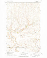
1969 Map of Harrington SE
USGS Topo · Published 1978About this map
Crab Creek and its South Fork carve through this section of the Channeled Scablands, defining a landscape of basalt coulees and plateaued benchlands. Recorded during a 1969 field check, the map reveals a sparsely populated agricultural and grazing region where infrastructure is dictated by the water. The Rocky Ford Bridge provides a vital crossing over the creek, while the presence of several Wells and a seasonal Spring indicate the importance of groundwater in this semi-arid terrain.
Find a feature on this map
18 named features on this map. Tap any name to fly to it.
Don’t see what you’re looking for? This feature index may not catch every label — zoom into the map to look around manually.
Map Details
Editions of this 1969 Harrington SE Map
2 editions found
Other maps of this area

1953 · Ritzville
USGS Topo · 1:250,000

1959 · Ritzville
USGS Topo · 1:250,000

1964 · Karakul Hills
USGS Topo · 1:24,000

1965 · Ritzville
USGS Topo · 1:250,000

1967 · Ritzville NE
USGS Topo · 1:24,000

1967 · Ritzville NW
USGS Topo · 1:24,000

1969 · Harrington
USGS Topo · 1:24,000

1969 · Lords Valley
USGS Topo · 1:24,000

1969 · Cormana Lake
USGS Topo · 1:24,000

1969 · Lamona
USGS Topo · 1:24,000