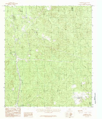
1984 Map of Harrisburg
USGS Topo · Published 1984About this map
Harrisburg and Browndell anchor this pocket of East Texas, where the landscape is defined by the dense dendritic drainage of the Big Cow Creek and Sandy Creek systems. Compiled from late 1970s aerial photography, the map reveals a rural economy shaped by extractive industry and timber management, evidenced by the numerous Gravel Pit sites and the Horton Lookout 2 tower. Small settlements like Horton and Collins are connected by a network of unimproved roads, while the Jasper Co Newton Co line cuts through the eastern portion of the quadrangle.
Find a feature on this map
24 named features on this map. Tap any name to fly to it.
Don’t see what you’re looking for? This feature index may not catch every label — zoom into the map to look around manually.
Map Details
Editions of this 1984 Harrisburg Map
This is the sole edition of this map. No revisions or reprints were ever made.
Other maps of this area

1952 · Lake Charles
USGS Topo · 1:250,000

1953 · Alexandria
USGS Topo · 1:250,000

1953 · Palestine
USGS Topo · 1:250,000

1954 · Lake Charles
USGS Topo · 1:250,000

1954 · Beaumont
USGS Topo · 1:250,000

1955 · Alexandria
USGS Topo · 1:250,000

1955 · Roganville
USGS Topo · 1:62,500

1955 · Curtis
USGS Topo · 1:62,500

1957 · Beaumont
USGS Topo · 1:250,000

1957 · Palestine
USGS Topo · 1:250,000