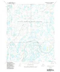
1955 Map of Harrison Bay A-3
USGS Topo · Published 1984About this map
The Colville River meanders across the North Slope in this mid-century survey, defining the southern boundary of the National Petroleum Reserve in Alaska. The landscape is dominated by a complex network of thermokarst lakes and braided watercourses, including the Ublutuoch River and Fish Creek. A solitary Winter Trail cuts across the tundra in the northern portion of the quadrangle, illustrating the seasonal nature of travel and transport in this Arctic environment before permanent infrastructure. Geologic and navigational landmarks such as the Bluff and Big Bend provide orientation along the river corridor, while Ocean Point stands as a notable geographic reference point in an otherwise shifting terrain of water and permafrost.
Find a feature on this map
8 named features on this map. Tap any name to fly to it.
Don’t see what you’re looking for? This feature index may not catch every label — zoom into the map to look around manually.
Map Details
Editions of this 1955 Harrison Bay A-3 Map
2 editions found
Other maps of this area

1951 · Harrison Bay
USGS Topo · 1:250,000

1952 · Umiat
USGS Topo · 1:250,000

1955 · Harrison Bay
USGS Topo · 1:250,000

1955 · Harrison Bay A-4
USGS Topo · 1:63,360

1955 · Harrison Bay B-3
USGS Topo · 1:63,360

1955 · Harrison Bay B-2
USGS Topo · 1:63,360

1955 · Umiat D-2
USGS Topo · 1:63,360

1955 · Harrison Bay A-2
USGS Topo · 1:63,360

1955 · Harrison Bay A-3
USGS Topo · 1:63,360

1955 · Harrison Bay B-4
USGS Topo · 1:63,360