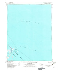
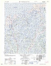
1955 Map of Harrison Bay C-3
USGS Topo · Published 1982About this map
Beaufort Sea waters dominate this coastal survey, where the frozen horizon of the Arctic meets the low-lying shoreline of the National Petroleum Reserve in Alaska. The landscape is characterized by a complex network of coastal mudflats and seasonal wetlands that transition into the shallow expanse of Harrison Bay. A single Well on the mainland suggests early industrial interest in this remote territory during the mid-1950s, a period before significant infrastructure arrived on the North Slope. Significant geographical markers like Atigaru Point provide critical reference points for navigating this feature-sparse coastline, where the interaction between the sea and the coastal plain is constantly reshaped by the elements.
Find a feature on this map
5 named features on this map. Tap any name to fly to it.
Don’t see what you’re looking for? This feature index may not catch every label — zoom into the map to look around manually.
Map Details
Editions of this 1955 Harrison Bay C-3 Map
3 editions found
Other maps of this area

1951 · Harrison Bay
USGS Topo · 1:250,000

1955 · Harrison Bay
USGS Topo · 1:250,000

1955 · Harrison Bay B-3
USGS Topo · 1:63,360

1955 · Harrison Bay D-4
USGS Topo · 1:63,360
1955 · Harrison Bay C-3
USGS Topo · 1:63,360

1955 · Harrison Bay B-2
USGS Topo · 1:63,360

1955 · Harrison Bay C-4
USGS Topo · 1:63,360

1955 · Harrison Bay B-4
USGS Topo · 1:63,360
1962 · Harrison Bay C-3
USGS Topo · 1:50,000
1962 · Harrison Bay B-2
USGS Topo · 1:50,000