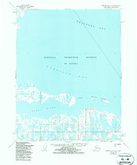
1955 Map of Harrison Bay C-4
USGS Topo · Published 1987About this map
The National Petroleum Reserve In Alaska dominates this 1955 survey of the Arctic coastline, where the Kogru River meets the expansive Harrison Bay. This remote landscape is defined by its seasonal transport and sparse human markers, featuring a Winter Trail that cuts across the permafrost and a strategically placed Landing Strip near the river's mouth. The presence of a Drill Hole in the southwest and survey points like Kogru E Base on the Eskimo Islands reflect the era's mid-century focus on energy exploration and geodetic mapping in the Far North.
Find a feature on this map
22 named features on this map. Tap any name to fly to it.
Don’t see what you’re looking for? This feature index may not catch every label — zoom into the map to look around manually.
Map Details
Editions of this 1955 Harrison Bay C-4 Map
3 editions found
Other maps of this area

1951 · Harrison Bay
USGS Topo · 1:250,000

1955 · Harrison Bay
USGS Topo · 1:250,000

1955 · Harrison Bay B-3
USGS Topo · 1:63,360

1955 · Harrison Bay D-4
USGS Topo · 1:63,360
1955 · Harrison Bay C-3
USGS Topo · 1:63,360

1955 · Harrison Bay C-5
USGS Topo · 1:63,360

1955 · Harrison Bay D-5
USGS Topo · 1:63,360

1955 · Harrison Bay B-5
USGS Topo · 1:63,360

1955 · Harrison Bay C-4
USGS Topo · 1:63,360

1955 · Harrison Bay B-4
USGS Topo · 1:63,360