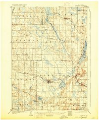
1904 Map of Hartford
USGS Topo · Published 1930About this map
Hartford and the surrounding townships of Dodge and Washington counties are defined here by a dense network of early 20th-century agriculture and rail infrastructure. Two major rail lines, the Chicago Milwaukee and St. Paul RR and the Wisconsin Central Railroad, cross the landscape, intersecting near the industrial and social hubs of the era. The terrain is marked by significant glacial water bodies, including Pike Lake and Cedar Lake, the latter featuring prominent landmarks such as Linden Pt., Lookout Pt., and Echo Pt.. To the south, the iconic landmark of Holy Hill rises above the Oconomowoc River valley. This 1901 survey reveals the distribution of smaller hamlets like Schleisingerville, Saylesville, and Kohlsville, providing a clear view of the regional economy before modern development altered the rural character of these southeastern Wisconsin communities.
Find a feature on this map
48 named features on this map. Tap any name to fly to it.
Don’t see what you’re looking for? This feature index may not catch every label — zoom into the map to look around manually.
Map Details
Editions of this 1904 Hartford Map
3 editions found
Other maps of this area

1892 · Waukesha
USGS Topo · 1:62,500

1892 · Watertown
USGS Topo · 1:62,500

1892 · Oconomowoc
USGS Topo · 1:62,500

1894 · Watertown
USGS Topo · 1:62,500

1901 · Waukesha
USGS Topo · 1:62,500

1904 · West Bend
USGS Topo · 1:62,500

1904 · Hartford
USGS Topo · 1:62,500

1906 · Waukesha
USGS Topo · 1:62,500

1909 · Oconomowoc
USGS Topo · 1:62,500

1955 · Waupun
USGS Topo · 1:62,500