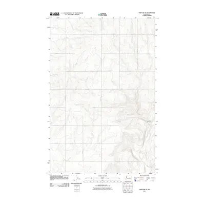
2011 Map of Hartline SE
USGS Topo · Published 2011About this map
Wilson Creek carves a winding path through this corner of Grant County, creating a distinct topographical contrast against the rigid grid of the surrounding high plateau. The landscape is defined by the intersection of deep-cut drainage coulees and the highly organized township-and-range road system, including Road 36 NE and Road 29 NE. This 2011 survey captures the area's agricultural and hydrological character, centered on water management features like the Russell Seig Dam. The vast network of rural routes, such as Road V NE and Road T NE, underscores the region's reliance on a precise transportation layout to navigate the complex elevation changes where the plateau drops toward the creek bed.
Find a feature on this map
16 named features on this map. Tap any name to fly to it.
Don’t see what you’re looking for? This feature index may not catch every label — zoom into the map to look around manually.
Map Details
Editions of this 2011 Hartline SE Map
This is the sole edition of this map. No revisions or reprints were ever made.
Other maps of this area

1953 · Ritzville
USGS Topo · 1:250,000

1956 · Wilson Creek NW
USGS Topo · 1:24,000

1956 · Wilson Creek
USGS Topo · 1:62,500

1959 · Ritzville
USGS Topo · 1:250,000

1965 · Ritzville
USGS Topo · 1:250,000

1968 · Hartline
USGS Topo · 1:24,000

1968 · Hartline SW
USGS Topo · 1:24,000

1968 · Marlin
USGS Topo · 1:24,000

1968 · Hartline SE
USGS Topo · 1:24,000
1968 · Hartline NW
USGS Topo · 1:24,000