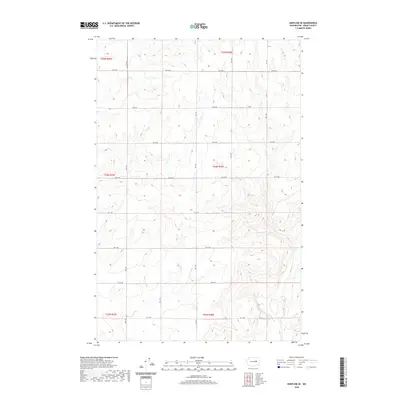
2020 Map of Hartline SE
USGS Topo · Published 2020About this map
Wilson Cr winds through the southeastern corner of this Grant County landscape, carving a path through the high plateau terrain. The region is defined by a rigorous grid of section lines and gravel roads, including RD 36 Ne and RD 29 Ne, reflecting the systematic agricultural development of the Big Bend country. Unlike more densely settled areas, the map reveals a vast, open territory punctuated by a Dirt Trl and a sparse network of thoroughfares like RD 33 Ne. The topographic contours illustrate the subtle drainage patterns and coulee-like formations typical of the Columbia Basin, showing how human activity here is strictly aligned with the Public Land Survey System divisions of T24N R30E and its neighboring townships.
Find a feature on this map
16 named features on this map. Tap any name to fly to it.
Don’t see what you’re looking for? This feature index may not catch every label — zoom into the map to look around manually.
Map Details
Editions of this 2020 Hartline SE Map
This is the sole edition of this map. No revisions or reprints were ever made.
Other maps of this area

1953 · Ritzville
USGS Topo · 1:250,000

1956 · Wilson Creek NW
USGS Topo · 1:24,000

1956 · Wilson Creek
USGS Topo · 1:62,500

1959 · Ritzville
USGS Topo · 1:250,000

1965 · Ritzville
USGS Topo · 1:250,000

1968 · Hartline
USGS Topo · 1:24,000

1968 · Hartline SW
USGS Topo · 1:24,000

1968 · Marlin
USGS Topo · 1:24,000

1968 · Hartline SE
USGS Topo · 1:24,000
1968 · Hartline NW
USGS Topo · 1:24,000