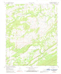
1967 Map of Hartshorne SW
USGS Topo · Published 1992About this map
Limestone Ridge and New State Mountain dominate this landscape in Pittsburg County, showing a rugged terrain where drainage systems like Peaceable Creek and Brushy Creek have carved distinct valleys. The area’s rural social fabric is anchored by small congregations at High Hill Ch, Peaceable Valley Ch, and Brushy Ch. Settlement patterns follow the lowlands and the remnants of industrial infrastructure, evidenced by an Old Railroad Grade and an Old Grade that suggest earlier eras of resource extraction or timber transport. Sparse settlements at Craig and Bond contrast with the natural landmarks of the southern reaches, most notably the Natural Arch and the adjacent Arch site. This 1960s survey records a moment of transition where traditional land use, represented by scattered cemeteries and gas wells, exists alongside newer utility corridors like the Pipeline crossing the central hills.
Find a feature on this map
28 named features on this map. Tap any name to fly to it.
Don’t see what you’re looking for? This feature index may not catch every label — zoom into the map to look around manually.
Map Details
Editions of this 1967 Hartshorne SW Map
2 editions found
Other maps of this area

1898 · McAlester
USGS Topo · 1:125,000

1909 · Mc Alester
USGS Topo · 1:125,000

1950 · Mcalester
USGS Topo · 1:250,000

1962 · McAlester
USGS Topo · 1:250,000

1965 · McAlester
USGS Topo · 1:250,000

1967 · Pittsburg
USGS Topo · 1:24,000

1967 · Krebs
USGS Topo · 1:24,000
1967 · Mc Alester
USGS Topo · 1:24,000
1967 · Adamson
USGS Topo · 1:24,000

1967 · Hartshorne SW
USGS Topo · 1:24,000