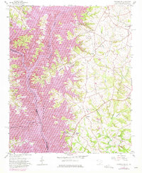
1959 Map of Hartwell NE
USGS Topo · Published 1975About this map
Lake Hartwell dominates this landscape, where the confluence of the Tugaloo River and Seneca River forms the headwaters of the Savannah River at the South Carolina-Georgia border. The 1959 data, updated with 1972 photorevisions, shows the impact of the reservoir on the terrain, particularly around the settlement of Andersonville. The eastern portion of the map is a dense network of rural infrastructure, including a notable concentration of country churches such as Lyle Memorial Ch, Roberts Ch, and Shiloh Ch. This area reflects the transition from river-valley agriculture to a reservoir-dominated economy, with land managed within the U S Res Bdy. Genealogists will find interest in the numerous cemeteries marked throughout the rolling hills of Anderson County, while the varied creek systems like Lightwood Log Creek and Generostee Creek illustrate the historical drainage patterns that defined local property lines.
Find a feature on this map
28 named features on this map. Tap any name to fly to it.
Don’t see what you’re looking for? This feature index may not catch every label — zoom into the map to look around manually.
Map Details
Editions of this 1959 Hartwell NE Map
4 editions found

Other maps of this area

1888 · Pickens
USGS Topo · 1:125,000

1893 · Elberton
USGS Topo · 1:125,000

1894 · Pickens
USGS Topo · 1:125,000

1950 · La France
USGS Topo · 1:24,000

1951 · La France
USGS Topo · 1:24,000

1954 · Greenville
USGS Topo · 1:250,000

1957 · Anderson
USGS Topo · 1:62,500

1958 · Greenville
USGS Topo · 1:250,000

1958 · Fair Play
USGS Topo · 1:24,000

1959 · Hartwell Dam
USGS Topo · 1:24,000