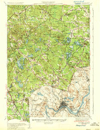
1935 Map of Haverhill
USGS Topo · Published 1935About this map
The Merrimack River bends through the heart of this landscape, serving as the industrial and transport anchor for Haverhill and Bradford. By the mid-1930s, the region shows a dense network of rail infrastructure, with the Main Line of B & M RR and the Georgetown Branch of B & M RR connecting riverside mills and manufacturing centers to the rural interior. In the hills to the north, the transition from industrial riverfront to upland recreation is evident around Canobie Lake and Island Pond, where Governors Island sits as a prominent landmark.
Find a feature on this map
152 named features on this map. Tap any name to fly to it.
Don’t see what you’re looking for? This feature index may not catch every label — zoom into the map to look around manually.
Map Details
Editions of this 1935 Haverhill Map
5 editions found

Other maps of this area

1886 · Lawrence
USGS Topo · 1:62,500

1886 · Lowell
USGS Topo · 1:62,500

1888 · Newburyport
USGS Topo · 1:62,500

1888 · Haverhill
USGS Topo · 1:62,500

1888 · Lawrence
USGS Topo · 1:62,500

1888 · Salem
USGS Topo · 1:62,500

1890 · Haverhill
USGS Topo · 1:62,500

1890 · Newburyport
USGS Topo · 1:62,500

1893 · Lowell
USGS Topo · 1:62,500

1893 · Dover
USGS Topo · 1:62,500