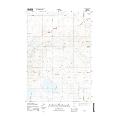
2016 Map of Hawick
USGS Topo · Published 2016About this map
Hawick serves as the central hub of this agricultural and lake-strewn landscape where Stearns, Kandiyohi, and Meeker counties meet. The area is defined by a dense concentration of glacial lakes and wetlands, including the expansive Lake Calhoun and the southwestern reach of Lake Koronis. For genealogists, the map is remarkably dense with historical landmarks, featuring four distinct burial grounds: Roseville Cem, Zion Lutheran Cem, Free Christians Cem, and Nordland Cem. Modern infrastructure like the Paynesville Byp and Paynesville Municipal Airport in the northeast corner shows the region's development alongside traditional landmarks like the Middle Fork Crow River. The road network, including Old Hwy 23, reflects the shift from early local routes to modern bypasses while maintaining the original township and range structure.
Find a feature on this map
54 named features on this map. Tap any name to fly to it.
Don’t see what you’re looking for? This feature index may not catch every label — zoom into the map to look around manually.
Map Details
Editions of this 2016 Hawick Map
This is the sole edition of this map. No revisions or reprints were ever made.
Other maps of this area

1953 · Saint Cloud
USGS Topo · 1:250,000

1956 · Atwater
USGS Topo · 1:62,500

1957 · Saint Cloud
USGS Topo · 1:250,000

1958 · Saint Cloud
USGS Topo · 1:250,000

1967 · Grove City
USGS Topo · 1:24,000

1967 · Paynesville
USGS Topo · 1:24,000

1967 · Lake Koronis
USGS Topo · 1:24,000
1967 · Georgeville
USGS Topo · 1:24,000

1967 · Hawick
USGS Topo · 1:24,000
1967 · Lake Henry
USGS Topo · 1:24,000