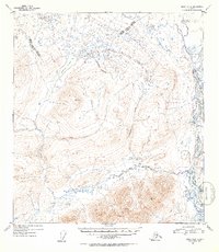
1952 Map of Healy A-2
USGS Topo · Published 1953About this map
Butte Lake sits at the heart of this Alaskan interior landscape, surrounded by high mountain peaks and a complex network of glacial drainages. Surveyed in the early 1950s, the terrain is defined by the massive Susitna River flowing along the eastern edge, joined by smaller tributaries like Windy Cr. The presence of a Sled Road cutting through the western portion of the quadrangle suggests the vital importance of seasonal overland travel before modern infrastructure reached this part of the Matanuska-Susitna region. High-altitude triangulation points, including VABM Watana 6187 and VABM Nadwen 5197, provide precise elevation benchmarks across the peaks. Waterways such as Butte Creek, Gold Creek, and Wickersham Creek carve through the landscape, illustrating the intricate watershed that feeds into the broader Susitna valley.
Find a feature on this map
13 named features on this map. Tap any name to fly to it.
Don’t see what you’re looking for? This feature index may not catch every label — zoom into the map to look around manually.
Map Details
Editions of this 1952 Healy A-2 Map
2 editions found

Other maps of this area

1949 · Healy B-2
USGS Topo · 1:63,360

1949 · Healy A-1
USGS Topo · 1:63,360

1950 · Talkeetna Mountains
USGS Topo · 1:250,000

1950 · Healy A-3
USGS Topo · 1:63,360

1950 · Healy B-3
USGS Topo · 1:63,360

1950 · Healy B-1
USGS Topo · 1:63,360

1951 · Healy
USGS Topo · 1:250,000

1951 · Talkeetna Mountains D-2
USGS Topo · 1:63,360

1951 · Talkeetna Mountains D-1
USGS Topo · 1:63,360

1951 · Talkeetna Mountains D-3
USGS Topo · 1:63,360