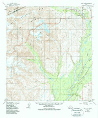
1949 Map of Healy A-6
USGS Topo · Published 1988About this map
The Alaska Railroad and the George Parks Highway carve a vital transportation corridor through the eastern edge of this territory, following the drainage of the West Fork Chulitna River. Small rail-side locations like Honolulu and Hurricane mark the human footprint in an otherwise massive expanse of peaks and glacial valleys. To the northwest, the Denali National Park and Preserve encompasses a landscape defined by high-altitude peaks like Joyce and Copeland. Local industrial history is anchored by the Silver King Mine and Golden Zone Mine in the northern reaches, while the drainage network of Ohio and Copeland Creek illustrates the complex hydrology fed by the high glaciers of the Alaska Range.
Find a feature on this map
32 named features on this map. Tap any name to fly to it.
Don’t see what you’re looking for? This feature index may not catch every label — zoom into the map to look around manually.
Map Details
Editions of this 1949 Healy A-6 Map
5 editions found
Other maps of this area

1949 · Talkeetna Mountains D-6
USGS Topo · 1:63,360

1949 · Healy A-6
USGS Topo · 1:63,360

1950 · Talkeetna Mountains
USGS Topo · 1:250,000

1950 · Talkeetna
USGS Topo · 1:250,000

1950 · Talkeetna Mountains D-5
USGS Topo · 1:63,360

1950 · Healy A-5
USGS Topo · 1:63,360

1950 · Healy B-5
USGS Topo · 1:63,360

1951 · Talkeetna
USGS Topo · 1:250,000

1951 · Healy
USGS Topo · 1:250,000

1951 · Talkeetna Mountains D-5
USGS Topo · 1:63,360