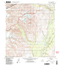
1949 Map of Healy A-6
USGS Topo · Published 1991About this map
Golden Zone Mine and the Silver King Mine anchor the northern reaches of this Alaskan interior landscape, where mineral extraction once sought to pull wealth from the high-elevation terrain. This mid-century survey captures a transit corridor in transition, defined by the Alaska Railroad and the George Parks Highway winding through the valley near Honolulu and Hurricane. The terrain is dominated by the West Fork Chulitna River and the massive flow of the Eldridge Glacier, which carves through the western mountains toward the Denali National Park and Preserve boundary. Small settlements like Honolulu are situated along the rail line, marking vital stops and maintenance points in the vast wilderness. The presence of Honolulu Road and marker Mile 290 illustrate the early infrastructure supporting the remote interior between the Alaska Range and the Matanuska-Susitna Borough boundary.
Find a feature on this map
35 named features on this map. Tap any name to fly to it.
Don’t see what you’re looking for? This feature index may not catch every label — zoom into the map to look around manually.
Map Details
Editions of this 1949 Healy A-6 Map
5 editions found
Other maps of this area

1949 · Talkeetna Mountains D-6
USGS Topo · 1:63,360

1949 · Healy A-6
USGS Topo · 1:63,360

1950 · Talkeetna Mountains
USGS Topo · 1:250,000

1950 · Talkeetna
USGS Topo · 1:250,000

1950 · Talkeetna Mountains D-5
USGS Topo · 1:63,360

1950 · Healy A-5
USGS Topo · 1:63,360

1950 · Healy B-5
USGS Topo · 1:63,360

1951 · Talkeetna
USGS Topo · 1:250,000

1951 · Healy
USGS Topo · 1:250,000

1951 · Talkeetna Mountains D-5
USGS Topo · 1:63,360