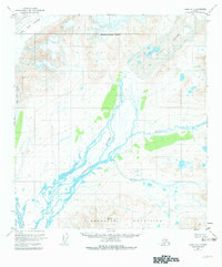
1950 Map of Healy B-1
USGS Topo · Published 1981About this map
The Susitna Glacier and West Fork Glacier dominate the upper reaches of this mid-century subarctic survey, marking the frozen origins of a complex glacial drainage system. As these massive ice sheets transition into the braided channels of the Susitna River, the landscape reveals a transition from alpine glaciation to a rugged riverine network within the Matanuska-Susitna Borough. To the south, the Clearwater Mountains rise sharply, providing a high-relief backdrop to the valley floor where the East Fork and Boulder Creek contribute to the glacial runoff. This map captures the region after 1949 aerial photography, illustrating a period of geological documentation before major infrastructure altered the wilderness character of the Alaska Interior.
Find a feature on this map
8 named features on this map. Tap any name to fly to it.
Don’t see what you’re looking for? This feature index may not catch every label — zoom into the map to look around manually.
Map Details
Editions of this 1950 Healy B-1 Map
4 editions found
Other maps of this area

1949 · Healy B-2
USGS Topo · 1:63,360

1949 · Healy A-1
USGS Topo · 1:63,360

1950 · Mount Hayes
USGS Topo · 1:250,000

1950 · Healy B-1
USGS Topo · 1:63,360

1950 · Mount Hayes A-6
USGS Topo · 1:63,360

1951 · Healy
USGS Topo · 1:250,000

1951 · Mount Hayes
USGS Topo · 1:250,000

1951 · Mount Hayes B-6
USGS Topo · 1:63,360

1951 · Healy C-1
USGS Topo · 1:63,360

1951 · Healy C-2
USGS Topo · 1:63,360