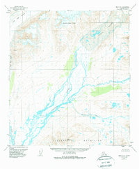
1950 Map of Healy B-1
USGS Topo · Published 1988About this map
The Susitna River carves a massive, braided path through this interior landscape, fed by the slow withdrawal of the Susitna Glacier and the West Fork Glacier. Surveyed in the middle of the twentieth century, the map reveals a wilderness shaped by ice and elevation, where the southern reaches are dominated by the Clearwater Mountains. High-altitude survey markers like VABM 6092 Teddy and VABM 5673 Sitna indicate the painstaking process of mapping this remote terrain within the Matanuska-Susitna Borough. The drainage patterns of the East Fork and Boulder Creek illustrate a complex watershed untouched by roads or permanent settlements at the time of the 1949 aerial photography. This sheet documents the raw geography of the Alaska Range's southern slopes before modern infrastructure reached these high valleys.
Find a feature on this map
10 named features on this map. Tap any name to fly to it.
Don’t see what you’re looking for? This feature index may not catch every label — zoom into the map to look around manually.
Map Details
Editions of this 1950 Healy B-1 Map
4 editions found
Other maps of this area

1949 · Healy B-2
USGS Topo · 1:63,360

1949 · Healy A-1
USGS Topo · 1:63,360

1950 · Mount Hayes
USGS Topo · 1:250,000

1950 · Healy B-1
USGS Topo · 1:63,360

1950 · Mount Hayes A-6
USGS Topo · 1:63,360

1951 · Healy
USGS Topo · 1:250,000

1951 · Mount Hayes
USGS Topo · 1:250,000

1951 · Mount Hayes B-6
USGS Topo · 1:63,360

1951 · Healy C-1
USGS Topo · 1:63,360

1951 · Healy C-2
USGS Topo · 1:63,360