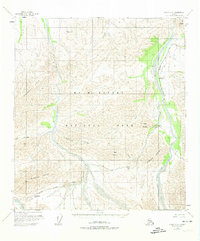
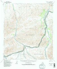
1954 Map of Healy C-6
USGS Topo · Published 1974About this map
Mc Kinley National Park topography dominates this mid-century survey, revealing the early infrastructure and high-mountain passes of the Alaska interior. The Mc Kinley Park Road—also labeled as Park Road—winds through the center of the sheet, providing the primary access point for the region's dramatic elevations. Travelers and early park visitors would have utilized the Teklanika Campground and Igloo Creek Campground as base points for traversing the high saddles of Sable Pass and Polychrome Pass. This map captures a landscape defined by braided glacial waterways, including the Teklanika River and the East Fork Toklat River, which cut through the Wyoming Hills and the slopes of Cathedral Mountain. The detailed contouring illustrates the steep ascent toward Mt Wright and Sable Mountain, providing an essential record of the park's early navigational routes.
Find a feature on this map
25 named features on this map. Tap any name to fly to it.
Don’t see what you’re looking for? This feature index may not catch every label — zoom into the map to look around manually.
Map Details
Editions of this 1954 Healy C-6 Map
6 editions found

Other maps of this area

1950 · Healy B-5
USGS Topo · 1:63,360

1951 · Healy
USGS Topo · 1:250,000

1951 · Healy B-5
USGS Topo · 1:63,360

1951 · Mount McKinley D-1
USGS Topo · 1:63,360

1951 · Healy D-6
USGS Topo · 1:63,360

1951 · Healy D-5
USGS Topo · 1:63,360

1952 · Healy D-5
USGS Topo · 1:63,360

1952 · Healy C-5
USGS Topo · 1:63,360

1952 · Mount McKinley
USGS Topo · 1:250,000

1952 · Mount McKinley B-1
USGS Topo · 1:63,360