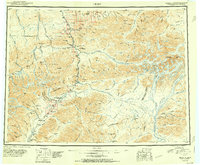
1951 Map of Healy
USGS Topo · Published 1951About this map
The Alaska Railroad serves as the industrial and logistical spine of this interior Alaskan landscape, connecting a string of rail-dependent settlements such as Healy, Cantwell, and Lignite. This early 1950s survey documents a region defined by its resource extraction and the preservation of its natural wonders, with the boundary of Mount McKinley National Park encompassing massive peaks like Fang Mtn and Double Mtn. Beyond the park's edge, the map identifies specific industrial sites including the Dunkle Coal Mine and Golden Zone Mine, providing a clear look at the era's mining footprint. Major glacial rivers like the Nenana River and Teklanika River dominate the drainage patterns, while specialized mountain passes like Polychrome Pass and Honolulu Pass indicate the early routes carved through the Alaska Range.
Find a feature on this map
151 named features on this map. Tap any name to fly to it.
Don’t see what you’re looking for? This feature index may not catch every label — zoom into the map to look around manually.
Map Details
Editions of this 1951 Healy Map
5 editions found

Other maps of this area

1948 · Kantishna River
USGS Topo · 1:250,000

1949 · Talkeetna Mountains D-6
USGS Topo · 1:63,360

1949 · Healy B-4
USGS Topo · 1:63,360

1949 · Big Delta A-6
USGS Topo · 1:63,360

1949 · Healy C-3
USGS Topo · 1:63,360

1949 · Healy B-2
USGS Topo · 1:63,360

1949 · Fairbanks A-2
USGS Topo · 1:63,360

1949 · Fairbanks A-1
USGS Topo · 1:63,360

1949 · Healy A-1
USGS Topo · 1:63,360

1949 · Healy D-1
USGS Topo · 1:63,360