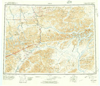
1951 Map of Healy
USGS Topo · Published 1957About this map
The Alaska Railroad serves as the industrial and logistical spine of this subarctic landscape, connecting isolated settlements like Healy and Suntrana during a period of active resource extraction. The map reveals a high concentration of mining activity near the northern rail corridor, specifically at the Dunkel Coal Mine and Lignite, where the proximity of coal deposits to the tracks shaped the early economy of the interior. Further south, the Golden Zone Mine sits nestled in the high peaks near Colorado, illustrating the difficult reach of early territorial prospecting.
Find a feature on this map
130 named features on this map. Tap any name to fly to it.
Don’t see what you’re looking for? This feature index may not catch every label — zoom into the map to look around manually.
Map Details
Editions of this 1951 Healy Map
5 editions found

Other maps of this area

1948 · Kantishna River
USGS Topo · 1:250,000

1949 · Talkeetna Mountains D-6
USGS Topo · 1:63,360

1949 · Healy B-4
USGS Topo · 1:63,360

1949 · Big Delta A-6
USGS Topo · 1:63,360

1949 · Healy C-3
USGS Topo · 1:63,360

1949 · Healy B-2
USGS Topo · 1:63,360

1949 · Fairbanks A-2
USGS Topo · 1:63,360

1949 · Fairbanks A-1
USGS Topo · 1:63,360

1949 · Healy A-1
USGS Topo · 1:63,360

1949 · Healy D-1
USGS Topo · 1:63,360