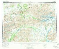
1956 Map of Healy
USGS Topo · Published 1970About this map
Mount McKinley National Park dominates the western landscape of this mid-century survey, showcasing the topographic complexity of the Alaska Range before modern expansion. The Alaska Railroad serves as the primary corridor for human activity, connecting a series of remote industrial and railway outposts like Healy, Suntrana, and Cantwell. This transportation spine mirrors the path of the Nenana River as it cuts through the mountains. Mining interests are clearly established in the northern hills, evidenced by the clustered settlements of Lignite and Usibelli, while the isolated Dunkle Mine sits deep in the southern reaches of the park boundary. The eastern half of the map reveals the broad, braided networks of the Susitna River and the Yanert Fork, illustrating the glacial drainage patterns typical of this subarctic interior. The presence of the Denali Highway and various mountain passes like Sable Pass and Windy Pass highlights the era’s vital overland routes through the wilderness.
Find a feature on this map
89 named features on this map. Tap any name to fly to it.
Don’t see what you’re looking for? This feature index may not catch every label — zoom into the map to look around manually.
Map Details
Editions of this 1956 Healy Map
4 editions found

Other maps of this area

1948 · Kantishna River
USGS Topo · 1:250,000

1949 · Talkeetna Mountains D-6
USGS Topo · 1:63,360

1949 · Healy B-4
USGS Topo · 1:63,360

1949 · Big Delta A-6
USGS Topo · 1:63,360

1949 · Healy C-3
USGS Topo · 1:63,360

1949 · Healy B-2
USGS Topo · 1:63,360

1949 · Fairbanks A-2
USGS Topo · 1:63,360

1949 · Fairbanks A-1
USGS Topo · 1:63,360

1949 · Healy A-1
USGS Topo · 1:63,360

1949 · Healy D-1
USGS Topo · 1:63,360