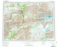
1956 Map of Healy
USGS Topo · Published 1981About this map
Healy and the surrounding Interior Alaska landscape are defined here by the critical corridor of the Alaska Railroad and the northern reaches of Denali National Park. The map documents a period of resource extraction and transit, centered on coal mining operations at Suntrana and Usibelli, connected to the main rail line near Lignite. The presence of the Dunkle Mine further west underscores the era's industrial activity in this alpine environment.
Find a feature on this map
80 named features on this map. Tap any name to fly to it.
Don’t see what you’re looking for? This feature index may not catch every label — zoom into the map to look around manually.
Map Details
Editions of this 1956 Healy Map
4 editions found

Other maps of this area

1948 · Kantishna River
USGS Topo · 1:250,000

1949 · Talkeetna Mountains D-6
USGS Topo · 1:63,360

1949 · Healy B-4
USGS Topo · 1:63,360

1949 · Big Delta A-6
USGS Topo · 1:63,360

1949 · Healy C-3
USGS Topo · 1:63,360

1949 · Healy B-2
USGS Topo · 1:63,360

1949 · Fairbanks A-2
USGS Topo · 1:63,360

1949 · Fairbanks A-1
USGS Topo · 1:63,360

1949 · Healy A-1
USGS Topo · 1:63,360

1949 · Healy D-1
USGS Topo · 1:63,360