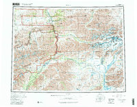
1956 Map of Healy
USGS Topo · Published 1981About this map
The Alaska Railroad serves as the industrial backbone of this central interior region, threading through the high peaks of the Alaska Range alongside the Nenana River. During the mid-twentieth century, the map reveals a landscape defined by coal extraction and transit, anchored by the mining community of Usibelli and the rail-dependent settlements of Suntrana and Healy. To the west, the early boundaries of Denali National Park and Wilderness Area encompass high-altitude landmarks like Polychrome Pass and Sable Mountain, while the southern reaches follow the rails toward Broad Pass. The transition from industrial corridors to wilderness is marked by remote outposts such as Cantwell and the Dunkle Mine, illustrating the era's reliance on river valleys and mountain gaps for access to mineral wealth and interior travel.
Find a feature on this map
108 named features on this map. Tap any name to fly to it.
Don’t see what you’re looking for? This feature index may not catch every label — zoom into the map to look around manually.
Map Details
Editions of this 1956 Healy Map
4 editions found

Other maps of this area

1948 · Kantishna River
USGS Topo · 1:250,000

1949 · Talkeetna Mountains D-6
USGS Topo · 1:63,360

1949 · Healy B-4
USGS Topo · 1:63,360

1949 · Big Delta A-6
USGS Topo · 1:63,360

1949 · Healy C-3
USGS Topo · 1:63,360

1949 · Healy B-2
USGS Topo · 1:63,360

1949 · Fairbanks A-2
USGS Topo · 1:63,360

1949 · Fairbanks A-1
USGS Topo · 1:63,360

1949 · Healy A-1
USGS Topo · 1:63,360

1949 · Healy D-1
USGS Topo · 1:63,360