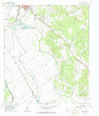
1961 Map of Hearne South
USGS Topo · Published 1987About this map
Hearne stands as a significant rail hub where the Missouri Pacific and Southern Pacific lines converge, shaping the economic landscape of this Robertson County region in the early 1960s. The map reveals a transition from the urban grid of the town to the broad alluvial plains between the Brazos River and the Little Brazos River. This fertile corridor is dotted with small agricultural settlements and rail stops like Sutton, Mumford, and Tatsie, many of which grew around river crossings such as Tatsie Crossing.
Find a feature on this map
42 named features on this map. Tap any name to fly to it.
Don’t see what you’re looking for? This feature index may not catch every label — zoom into the map to look around manually.
Map Details
Editions of this 1961 Hearne South Map
3 editions found
Other maps of this area

1954 · Austin
USGS Topo · 1:250,000

1956 · Bryan
USGS Topo · 1:62,500

1956 · Caldwell
USGS Topo · 1:62,500

1961 · Mumford
USGS Topo · 1:24,000

1961 · Hearne North
USGS Topo · 1:24,000

1961 · Hearne South
USGS Topo · 1:24,000

1962 · Goodwill
USGS Topo · 1:24,000

1962 · Calvert
USGS Topo · 1:24,000

1962 · Wheelock
USGS Topo · 1:24,000
1962 · Gause
USGS Topo · 1:24,000