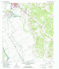
1961 Map of Hearne South
USGS Topo · Published 1989About this map
The confluence of the Brazos River and the Little Brazos River creates a wide, fertile floodplain south of Hearne, where 1960s agriculture and early 1980s expansion are visible through photorevised updates. The Southern Pacific Railroad acts as a central spine through the landscape, connecting settlements like Sutton and Mumford to the regional hub at Hearne. This map records a landscape shaped by both the river and the rail, including distinct community nodes at Tatsie Crossing and Nicholas. For the family historian, the sheet is particularly valuable for its detail on local institutions, including Union Chapel, Wilson Chapel, and cemeteries such as St Luke Cem and Galloway Cem. Terrain features like Suggs Mountain rise above the alluvial plains, while the presence of Gravel Pits and numerous storage bins along the rail lines highlights the local extraction and agricultural economy of the era.
Find a feature on this map
32 named features on this map. Tap any name to fly to it.
Don’t see what you’re looking for? This feature index may not catch every label — zoom into the map to look around manually.
Map Details
Editions of this 1961 Hearne South Map
3 editions found
Other maps of this area

1954 · Austin
USGS Topo · 1:250,000

1956 · Bryan
USGS Topo · 1:62,500

1956 · Caldwell
USGS Topo · 1:62,500

1961 · Mumford
USGS Topo · 1:24,000

1961 · Hearne North
USGS Topo · 1:24,000

1961 · Hearne South
USGS Topo · 1:24,000

1962 · Goodwill
USGS Topo · 1:24,000

1962 · Calvert
USGS Topo · 1:24,000

1962 · Wheelock
USGS Topo · 1:24,000
1962 · Gause
USGS Topo · 1:24,000