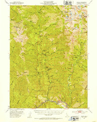
1951 Map of Helena
USGS Topo · Published 1953About this map
Helena and the Trinity River corridor anchor this mid-century look at one of California's most active gold mining districts. The 1951 field check reveals a landscape deeply marked by extraction, from the clustered claims along the river at Idaho Bar and Coopers Bar to hard-rock operations in the high country. Significant lode mining sites like the Enterprise Mine, Yellowstone Mine, and McClaron Mine are located throughout the Trinity National Forest, illustrating the remote nature of these industrial outposts.
Find a feature on this map
129 named features on this map. Tap any name to fly to it.
Don’t see what you’re looking for? This feature index may not catch every label — zoom into the map to look around manually.
Map Details
Editions of this 1951 Helena Map
5 editions found

Other maps of this area

1886 · Shasta
USGS Topo · 1:250,000

1890 · Red Bluff
USGS Topo · 1:250,000

1894 · Red Bluff
USGS Topo · 1:250,000

1894 · Shasta
USGS Topo · 1:250,000

1909 · Big Bar
USGS Topo · 1:96,000

1913 · Weaverville
USGS Topo · 1:125,000

1915 · Big Bar and Vicinity
USGS Topo · 1:250,000

1923 · Sawyers Bar
USGS Topo · 1:125,000

1931 · Etna
USGS Topo · 1:96,000

1934 · Etna
USGS Topo · 1:125,000