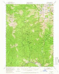
1951 Map of Helena
USGS Topo · Published 1966About this map
The North Fork Trinity River and its rugged tributaries define this mid-century look at the gold-mining history of the Trinity National Forest. The map documents a landscape transitioning from active extraction to memory, marking formerly significant settlements as Canyon City (Site) and Coleridge (Site). The concentration of hard-rock mining is evident along the eastern gulches, where claims like the Alaska Mine, Enterprise Mine, and Mason & Thayer Mine are recorded alongside the Dedrick Lookout.
Find a feature on this map
125 named features on this map. Tap any name to fly to it.
Don’t see what you’re looking for? This feature index may not catch every label — zoom into the map to look around manually.
Map Details
Editions of this 1951 Helena Map
5 editions found

Other maps of this area

1886 · Shasta
USGS Topo · 1:250,000

1890 · Red Bluff
USGS Topo · 1:250,000

1894 · Red Bluff
USGS Topo · 1:250,000

1894 · Shasta
USGS Topo · 1:250,000

1909 · Big Bar
USGS Topo · 1:96,000

1913 · Weaverville
USGS Topo · 1:125,000

1915 · Big Bar and Vicinity
USGS Topo · 1:250,000

1923 · Sawyers Bar
USGS Topo · 1:125,000

1931 · Etna
USGS Topo · 1:96,000

1934 · Etna
USGS Topo · 1:125,000