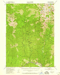
1951 Map of Helena
USGS Topo · Published 1959About this map
The Trinity Alps define the northern reaches of this survey, where dramatic peaks like Thompson Peak and Wedding Cake overlook alpine features such as Mirror Lake and Sapphire Lake. This mid-century map documents a landscape heavily influenced by the California gold rush legacy, centered around the North Fork of the Trinity River. Settlement is sparse, characterized by mining camps and remote outposts. The southern half reveals the industrial imprint of the era, notably around Dedrick and the former locations of Canyon City and Coleridge. A dense network of lode and placer mines, including the Alaska Mine, Enterprise Mine, and the Mason & Thayer Mine, follows the drainage of Canyon Creek. High-elevation landmarks like the Backbone Ridge Lookout and Dedrick Lookout underscore the management of the surrounding Trinity National Forest.
Find a feature on this map
117 named features on this map. Tap any name to fly to it.
Don’t see what you’re looking for? This feature index may not catch every label — zoom into the map to look around manually.
Map Details
Editions of this 1951 Helena Map
5 editions found

Other maps of this area

1886 · Shasta
USGS Topo · 1:250,000

1890 · Red Bluff
USGS Topo · 1:250,000

1894 · Red Bluff
USGS Topo · 1:250,000

1894 · Shasta
USGS Topo · 1:250,000

1909 · Big Bar
USGS Topo · 1:96,000

1913 · Weaverville
USGS Topo · 1:125,000

1915 · Big Bar and Vicinity
USGS Topo · 1:250,000

1923 · Sawyers Bar
USGS Topo · 1:125,000

1931 · Etna
USGS Topo · 1:96,000

1934 · Etna
USGS Topo · 1:125,000