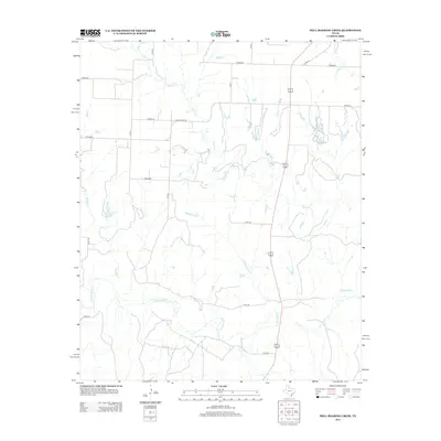
2013 Map of Hell Roaring Creek
USGS Topo · Published 2013About this map
The N Pease River corridor defines the southern reaches of this Cottle County landscape, where an intricate network of intermittent tributaries drains the Texas plains. The eponymous Hell Roaring Cr joins Sweetwater Cr and Shores Cr in a complex hydrological system that shapes the local topography. This 2013 survey illustrates a sparsely populated ranching region partitioned by a geometric grid of rural routes, including Co Road BB and Ranch Road 2103. A notable landmark in this arid environment is Groclose Lake, a small body of water situated near Devils Cr. The map captures the quiet, rural character of the region, showing how modern transportation routes like US Highway 62/83 overlay the traditional land divisions of the Texas Panhandle.
Find a feature on this map
21 named features on this map. Tap any name to fly to it.
Don’t see what you’re looking for? This feature index may not catch every label — zoom into the map to look around manually.
Map Details
Editions of this 2013 Hell Roaring Creek Map
This is the sole edition of this map. No revisions or reprints were ever made.
Other maps of this area
1954 · Plainview
USGS Topo · 1:250,000
1958 · Plainview
USGS Topo · 1:250,000
1966 · Cee Vee
USGS Topo · 1:24,000
1967 · Buckle L Ranch
USGS Topo · 1:24,000
1967 · Tell South
USGS Topo · 1:24,000
1967 · Hell Roaring Creek
USGS Topo · 1:24,000
1967 · Tell North
USGS Topo · 1:24,000
1967 · Dunlap
USGS Topo · 1:24,000
1967 · Childress
USGS Topo · 1:24,000
1967 · Carey
USGS Topo · 1:24,000