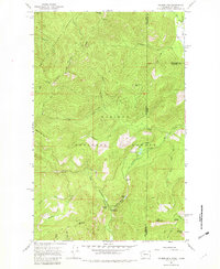
1967 Map of Helmer Mtn
USGS Topo · Published 1982About this map
Roosevelt Grove of Ancient Cedars stands as a central landmark within this 1967 survey of the high country straddling the Washington and Idaho border. The terrain is defined by the sharp divide between the Colville National Forest and Kaniksu National Forest, where a network of trails and primitive routes provide access to the remote peaks. Water flows through steep drainages like Sullivan Creek and Gold Creek, while higher elevations feature isolated bodies such as Muskegon Lake and Playa Lake. The map details the transition from the deep Packrat Gorge and Granite Pass to several prominent summits, including Helmer Mountain and Jackson Mtn. This document serves as a record of the wilderness recreation and conservation efforts in the Selkirk region during the mid-20th century, anchored by the presence of the Stagger Inn Campground.
Find a feature on this map
40 named features on this map. Tap any name to fly to it.
Don’t see what you’re looking for? This feature index may not catch every label — zoom into the map to look around manually.
Map Details
Editions of this 1967 Helmer Mtn Map

Other maps of this area

1911 · Priest Lake
USGS Topo · 1:250,000

1913 · Priest Lake
USGS Topo · 1:250,000

1934 · Metaline
USGS Topo · 1:125,000

1942 · Metaline
USGS Topo · 1:125,000

1958 · Sandpoint
USGS Topo · 1:250,000

1963 · Sandpoint
USGS Topo · 1:250,000

1967 · Gypsy Peak
USGS Topo · 1:24,000

1967 · Salmo Mtn.
USGS Topo · 1:24,000

1967 · Priest Lake NW
USGS Topo · 1:24,000

1967 · Monumental Mtn.
USGS Topo · 1:24,000