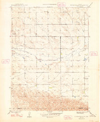
1948 Map of Hemingford 4 SW
USGS Topo · Published 1948About this map
Snake Creek meanders through the heart of this High Plains landscape, accompanied by the drainage of Barrel Springs Creek to the north. Surveyed shortly after World War II, the area reveals a sparse rural settlement pattern typical of the Nebraska Panhandle, where water management and education were the primary anchors of the community. The map identifies multiple local centers of learning, including School No 22, School No 23, and School No 36, serving the scattered farmsteads.
Find a feature on this map
12 named features on this map. Tap any name to fly to it.
Don’t see what you’re looking for? This feature index may not catch every label — zoom into the map to look around manually.
Map Details
Editions of this 1948 Hemingford 4 SW Map
4 editions found
Other maps of this area

1898 · Camp Clarke
USGS Topo · 1:125,000

1948 · Hemingford 4 SW
USGS Topo · 1:24,000

1948 · Hemingford 4 SE
USGS Topo · 1:24,000

1948 · Hemingford 4 NE
USGS Topo · 1:24,000

1948 · Hemingford 4 NW
USGS Topo · 1:24,000

1951 · Kilpatrick Lake
USGS Topo · 1:62,500

1954 · Scottsbluff
USGS Topo · 1:250,000

1955 · Alliance
USGS Topo · 1:250,000

1957 · Alliance
USGS Topo · 1:250,000

1958 · Alliance
USGS Topo · 1:250,000