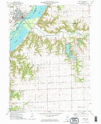
1972 Map of Henry
USGS Topo · Published 1974About this map
The Illinois River dominates this landscape, carving a wide valley between the town of Henry and the uplands of Magnolia. Along the western bank, the town’s grid is anchored by the High School and the Fairground, while the lowlands are defined by backwater features like Sawmill Lake, Whitney Lake, and Billsbach Lake. The eastern bluffs rise sharply from the water, revealing a more rural pattern of winding roads and small family cemeteries that speak to the area's pioneer heritage.
Find a feature on this map
38 named features on this map. Tap any name to fly to it.
Don’t see what you’re looking for? This feature index may not catch every label — zoom into the map to look around manually.
Map Details
Editions of this 1972 Henry Map
2 editions found
Other maps of this area

1893 · Lacon
USGS Topo · 1:62,500

1893 · Metamora
USGS Topo · 1:62,500

1933 · Lacon
USGS Topo · 1:62,500

1934 · Wenona
USGS Topo · 1:48,000

1937 · Metamora
USGS Topo · 1:62,500

1937 · Lacon
USGS Topo · 1:62,500

1939 · Wenona
USGS Topo · 1:62,500

1948 · Metamora
USGS Topo · 1:62,500

1955 · Minonk
USGS Topo · 1:62,500

1958 · Aurora
USGS Topo · 1:250,000